Savannah, Ga. – Sometimes called the “graveyard of the Atlantic” because of the large number of shipwrecks there, the waters off Cape Hatteras on the North Carolina coast are some of the least understood on U.S.’s eastern seaboard. University of Georgia Skidaway Institute of Oceanography scientist Dana Savidge is leading a team, which includes UGA Skidaway Institute scientist Catherine Edwards, to investigate the dynamic forces that characterize those waters.
The four-year project, informally called PEACH: Processes driving Exchange at Cape Hatteras, is funded by $5 million grant from the National Science Foundation. Skidaway Institute will receive $1.2 million for its part.
PEACH will focus primarily on the physics of the ocean, but the information the researchers gather will also help scientists more fully understand the chemistry and biology, and may cast light on issues like carbon cycling and global climate change.
“Everyone is interested in the global carbon budget, and the effect of the coastal seas on that budget is not well understood,” Savidge said. “For example, many scientists consider the continental shelf to be a sink for carbon, because there is a lot of biology going on and it draws in carbon.
“However, there are indications that the shelf south of Hatteras is both a sink and a source of carbon. This project may help clarify that picture.”
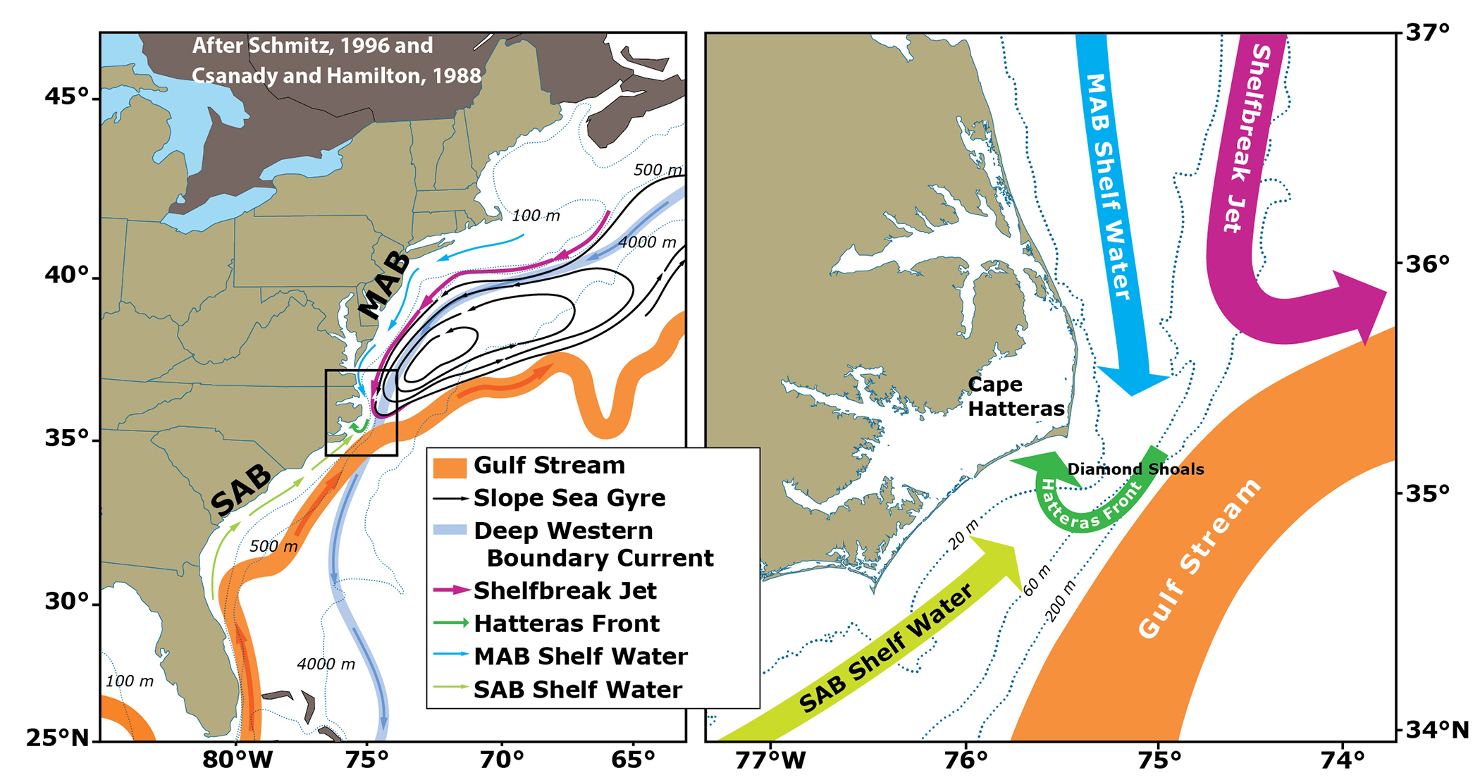
Two opposing deep ocean currents collide at Cape Hatteras, making the Atlantic Ocean near there highly dynamic. The warm Gulf Stream hugs the edge of the continental shelf as it flows north from the tip of Florida. At Cape Hatteras, it opposes a colder current, the Slope Sea Gyre current, that moves southward along the mid-Atlantic coast and breaks away from the coast toward northern Europe. As in the deep ocean, the cool shelf waters of the mid-Atlantic continental shelf meet the warm salty shelf waters from the south at Cape Hatteras.
The convergence of all of these currents at one place means that, after long lifetimes in the sunlit shallow shelves, these waters may export large quantities of organic carbon-small plants and animals that have grown up on the shelf-to the open ocean. Scientists have little understanding of the details of how that happens and how it is controlled by the high-energy winds, waves and interaction the between the constantly changing Gulf Stream and Slope Sea Gyre currents.
According to Savidge, the area is very difficult to observe because the water is shallow, the sea-state can be challenging and the convergence of strong currents at one place make it hard to capture features of interest.
“It’s difficult to get enough instruments in the water because conditions change rapidly over short distances, and it’s hard to keep them there because conditions are rough,” she said. “Ships work nicely for many of these measurements, but frequently, the ships get chased to shore because of bad weather.”
To overcome the limitations of ship-based work, the research team will use a combination of both shore- and ocean-based instruments to record the movement and characteristics of the streams of water. A system of high-frequency radar stations will monitor surface currents on the continental shelf all the way out to the shoreward edge of the Gulf Stream, providing real-time maps of surface currents.
“Measuring surface currents remotely with the radars is a real advantage here,” Savidge said. “They cover regions that are too shallow for mobile vehicles like ships to operate while providing detailed information over areas where circulation can change quite dramatically over short times and distances.”
Edwards will lead a robotic observational component in which pairs of autonomous underwater vehicles called gliders will patrol the shelf to the north and south of Cape Hatteras. Packed with instruments to measure temperature, salinity, dissolved oxygen and bio-optical properties of the ocean, both shelf- and deep-water gliders fly untethered through the submarine environment, sending their data to shore at regular intervals via satellite.
To compensate for the notoriously difficult conditions, Edwards will take advantage of a novel glider navigation system she developed with students and collaborators at Georgia Tech that automatically adjusts the glider mission based on ocean forecasts as well as data collected in real time.
“Our experiments show that we can keep the gliders where they need to be to collect the data we need,” she said. “The best part is that we get to put the maps of surface currents together with the subsurface information from the gliders, and we can make all of this information available in real time to scientists, fishermen and the general public.”
The researchers will also place a number of moorings and upward-pointing echo sounders on the sea floor. These acoustic units will track water movement and record temperature and density.
The project will run through March 2020. The remaining members of the research team are Harvey Seim and John Bane of the University of North Carolina; Ruoying He of North Carolina State University; and Robert Todd, Magdalena Andres and Glen Gawarkiewicz from Woods Hole Oceanographic Institute.