
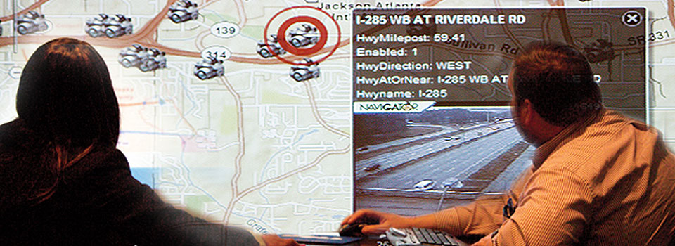
For the Georgia Emergency Management Agency, geographic information systems (GIS) aren’t just for the technology-minded-they’re critical to helping the state plan for its next disaster.
“It’s ‘GIS for dummies’,” says Terry Lunn, hazard mitigation director at GEMA. Live weather feeds and traffic conditions can be layered over maps of Georgia cities and counties, allowing planners to assess potential hazards and vulnerabilities even if they lack a high-tech background.
The technology was developed by the Information Technology Outreach Services (ITOS) division of the Carl Vinson Institute of Government. Using historical weather data, as well as topographical characteristics, the programs predict which areas are most susceptible to natural disasters, so that planners can take proactive steps to reduce damage.
“A lot of it is for planning purposes,” Lunn says. “Where to spend mitigation dollars, how to strengthen infrastructure. GIS helps with all of that.”
ITOS also maps the locations of government-owned buildings and the sites of critical facilities, such as hospitals, sheriff’s offices and schools, so that GEMA has plans of action in case a hospital is flooded or the county’s only jail is destroyed by a hurricane.
“You’ve been hit by a class five hurricane, what do you do? You know what to do. You’re not having to sit there and guess,” says Eric McRae (BS ’98), associate director of ITOS. “Basically you take information, whether it’s government info, business info, whatever, and analyze it using the geography as another field.”
When the data are combined, information that would otherwise be difficult to process suddenly makes more sense.
Jennifer Frum (PhD ’09), interim director of CVIOG, says that ITOS “uses technology to make information more accessible to people… to make large amounts of data visual and easier to understand.”
Even though they are using historical hazard information when collecting data, ITOS is working to keep all of its systems as current as possible and shift to meet their customers’ needs.
“Everybody’s looking for more online information. They want to have quicker access and easier access to their information,” McRae says. Servers that were once kept in isolated areas are now available for employees in different locations and agencies to connect to, modify and add data, and manipulate the information for their benefit.
And Frum says increasingly technology-literate citizens are also demanding the information ITOS provides.
“There are demands by the public to make information more accessible and to be more transparent with public information,” she says. “And I think that’s what ITOS is really, really good at.”